Transportation Analysis
The Slate Belt has experienced increased traffic and quality of life impacts from development in adjoining municipalities and along the Route 33 corridor. Many of the critical roads in the area are owned by the State and are not under local control.
Plan Slate Belt will need to examine current and anticipated transportation, travel, recreational and infrastructure needs to balance maintenance and investment to achieve a resilient system.
A Transportation Analysis was performed to examine current transportation infrastructure and operational conditions. Data was gathered on the existing transportation network, average daily traffic and crash patterns. The analysis consisted of comparing concerns identified by the community to the available data to identify other issues in the region.
Existing Transportation Network
Mixed-Transportation Network
The existing transportation network consists of state and local roads, sidewalks, LANTA routes and multi-use trails. LANTA provides public bus service along Sullivan Trail and along Route 512 through Wind Gap, Plainfield Township, Pen Argyl, Bangor and Roseto.
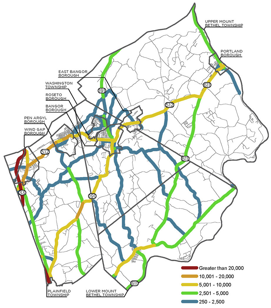
Vehicles Per Day
The existing transportation network carries the highest traffic volumes within the Route 33 corridor. This corridor’s primary function is to move traffic. Other corridors such as Route 512, Route 191 and Route 611 carry moderate volumes in comparison.
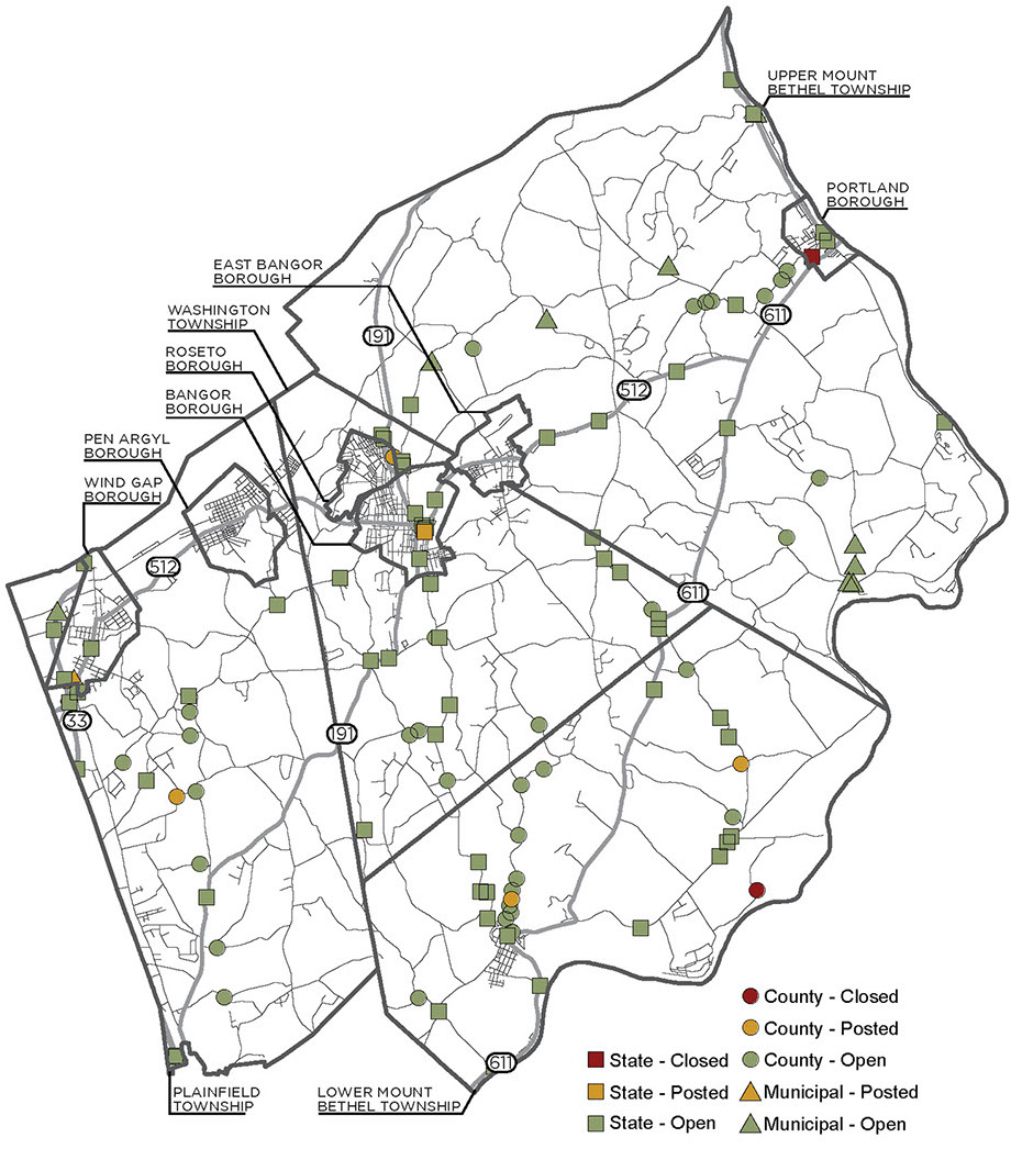
Bridge Condition
There are a total of 115 bridges that are eight feet or longer in the region—six bridges are posted with weight restrictions, and two bridges are closed (Depues Ferry Road Bridge in Lower Mount Bethel Township and Jacoby Creek Bridge in Portland Borough).
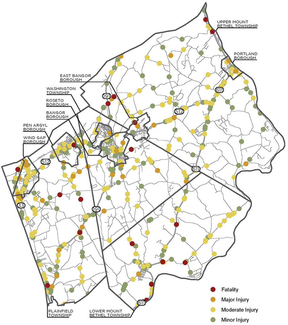
Crashes
There were 1,707 crashes between 2013 and 2017. They included fatalities, major injuries, moderate injuries and minor injuries. Non-reportable crashes are not included. Crashes tend to be clustered within the boroughs and along major roads.
Transportation Concerns
Municipal Transportation Concerns
The Slate Belt municipalities were asked to identify the three largest transportation issues within their community. These locally identified issues were compared to crash report data, traffic volumes and congestion, and bridge status data collected by the LVPC, PennDOT and other agencies. The results show a strong correlation between local perceptions of transportation issues and available data, enabling Plan Slate Belt to have a better understanding of these transportation impacts. The findings are broken out by municipality below.
Slate Belt Transportation Concerns
Municipalities were also asked to identify their three largest transportation issues within the Slate Belt area. Together, the municipalities identified ten area issues—most of which aligned with issues identified locally by their respective municipalities. Municipalities also ranked their top three regional transportation priorities. These rankings were combined to create a regional ranking of the concerns identified.
The identified regional issues were compared to transportation information collected by the LVPC, PennDOT and other agencies to get a better understanding of the local concerns in context of available data. The results show a strong correlation between local perceptions of transportation issues and collected data.
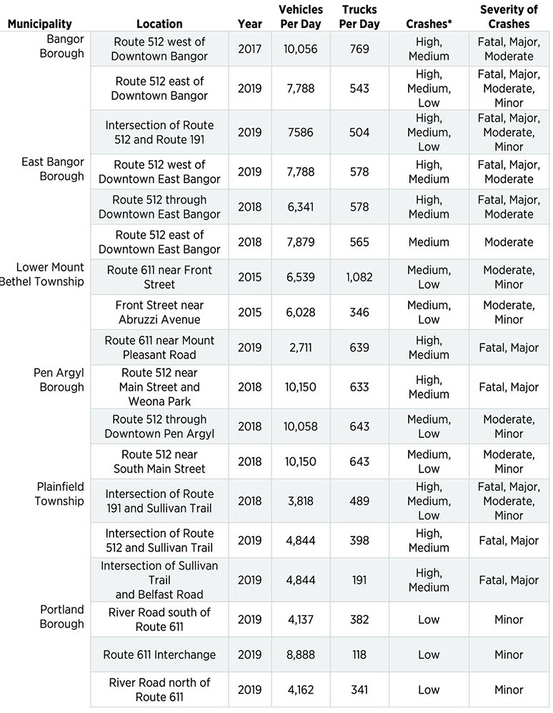
Municipal Transportation Concerns
BANGOR BOROUGH
Bangor Borough identified both the Route 512 corridor west out of downtown (to Weis Market), the Route 512 corridor east out of downtown (to Bill Scott Boulevard), and the intersection of Route 512 and Route 191 as having pedestrian safety, truck traffic and other transportation issues. These concerns were verified by the transportation data indicating a medium to high number of crashes along these two corridors. These safety issues are likely due to the high average daily traffic volumes in the area and the many turns the routes take through Downtown Bangor Borough.
The municipally also identified the lack of LANTA service to the south side (Third Ward) of the community as a transportation concern. LANTA service does exist along Route 512 and north along Route 191 into Roseto, but does not exist in the south side of Bangor. Sidewalk quality and topography could be an issue for people trying to reach LANTA from this neighborhood.
EAST BANGOR BOROUGH
East Bangor Borough also identified multiple traffic concerns along Route 512. Speeding was noted as a perceived issue in the Route 512 corridor (to Broad Street), and traffic data in this area shows high daily traffic volumes. The combination of these two factors is likely the cause of the medium to high rate of crashes along this corridor.
A truck issue was identified at the intersection of Route 512 and Capital Boulevard, caused by dump trucks going to the quarry. Traffic count data collected for this intersection in 2016 showed an average count of 578 trucks traveling through the intersection per day. This high volume of truck traffic in combination with the high volumes of daily traffic may be the cause of the medium to high rate of crashes reported in the area.
A safety issue was identified at the Route 512 and Park Road intersection, where a sharp curve and high daily traffic volumes may be the cause of the medium to high rate of crashes reported in the area.
The municipality also identified the lack of LANTA service to the Borough as a transportation concern.
LOWER MOUNT BETHEL TOWNSHIP
Lower Mount Bethel Township expressed safety concerns in and around the Martins Creek village center and along Route 611. These concerns are due to increasing freight-related truck traffic and were verified by the traffic count data showing that trucks made up 15% of the total traffic flow in 2015.
Data for the Route 611 and Front Street intersection and the Front Street to Abruzzi Avenue corridor indicated a low to medium crash rate, despite having high daily traffic volumes. Therefore, these areas will require further assessment to determine the traffic impacts.
Conversely, crash data for the Route 611 corridor through the Township reported a medium to high crash rate, despite having a medium level of daily traffic volumes.
PEN ARGYL BOROUGH
Pedestrian safety was a reported concern at the Route 512 and Main Street intersection. This perception is supported by data showing a medium to high rate of crashes and very high daily traffic volumes. It is likely that increases in traffic in the area will magnify these transportation concerns in the future.
On North Lobb Avenue, freight issues were reported due to truck usage on the municipal road. Truck traffic counts are not available for this location, and therefore, further assessment is required to determine the impact of high amounts of truck traffic on the local roadway. General traffic data in this area shows low to medium reported crashes, despite very high daily traffic volumes.
Flooding and icy roads were cited as a concern at the intersection of Route 512 and South Main Street. This poses a safety hazard for the very high daily volume of traffic in the area and may be the cause of the medium to high rate of crashes.
PLAINFIELD TOWNSHIP
Pedestrian safety was the main concern reported where Sullivan Trail intersects with Route 191, as well as the intersection at Belfast Road. These sentiments are supported by the medium to high rate of reported crashes.
Traffic congestion and bad sight distance were issues of concern at the intersection of Route 512 and Sullivan Trail. These concerns were verified by the medium to high rate of reported crashes, which are likely related to the very high daily traffic volumes.
PORTLAND BOROUGH
Portland Borough identified three intersections with safety concerns: Route 611 and River Road, the Route 611 Interchange, and the River Road and Delaware Avenue intersection. These intersections reported low crash rates, despite moderate to high volumes of daily traffic. Additional traffic concerns are two nearby bridges within Upper Mount Bethel Township on River Road. These two bridges have been identified as needing rehabilitation or replacement, posing a safety hazard to the increasing traffic in the area.
ROSETO BOROUGH
Freight traffic was identified as an issue at the Route 512 and Kennedy Drive intersection, as well as along the Route 191 corridor. Specific truck traffic data was not available in this area to verify local observations, so further assessment is required to determine the impact of freight on the roadway network. However, different sections of the corridor were found to have low, medium and high rates of crashes, with very high daily traffic volumes throughout the corridor.
Speeding was identified as an issue on the Route 512 corridor from Slate Belt Boulevard to Front Avenue. This is likely attributable to the low volumes of daily traffic in the area. As a result, this corridor has reported a medium rate of crashes.
UPPER MOUNT BETHEL TOWNSHIP
Freight issues were the main concern at the Route 512 and Route 611 intersection, as well as along the Route 611 to Potomac Street corridor. Truck traffic data was not available to verify this assessment. However, the area was found to have a high rate of crashes, despite only moderate levels of daily traffic.
Safety was cited as the primary issue along the Route 611 to Orchard Avenue corridor. This sentiment was supported by the reports of medium to high crash rates, despite only having low to medium traffic.
A steep slope located at the River Road and Riverton Road intersection is the cause of traffic concern and may contribute to the corridor having a high crash rate, despite only having low daily traffic volumes.
WASHINGTON TOWNSHIP
At the Route 512 and Kennedy Drive location, truck traffic related to freight movements was an issue of concern. Because truck traffic counts are not available for this location, further assessment is needed to quantify the impacts of freight on the roadway. A medium to high rate of crashes was reported at this location. The current daily traffic is considered moderate.
At the Lower South Main and True Blue Road intersection, stormwater was a cited concern. Water runoff during the winter freezes over and creates dangerous conditions for the moderate volume of daily traffic. However, no crashes have been reported in this area.
A safety issue was identified at the Route 191 and O W Road intersection due to a sharp curve with limited signage. However, no crashes have been reported in this area, and the average daily traffic volume is low.
WIND GAP BOROUGH
Wind Gap Borough identified three congestion and safety concern areas: the intersections of Route 512 and Male Road, Route 512 and Sullivan Trail, and Route 512 and Broadway. These local observations were validated by all three of these intersections having reported high rates of crashes.
*Different sections of the same corridor can have High, Medium or Low crashes. The table reflects all the different crash conditions along the selected segment.
Slate Belt Transportation Concerns
Route 512 Near Broadway and Route 512 and Male Road
The Route 512 and Male Road intersection and Route 512 Broadway corridor are located in Wind Gap Borough. They are in close proximity to each other. Safety was identified as the issue due to traffic congestion, and the intersection was ranked #1 by the municipalities. The corridor was tied for #9 by the municipalities. Crashes are high at this intersection, supporting community perceptions. However, crashes along the corridor are in the medium to low category.
Route 512 and Route 611
This Upper Mount Bethel Township intersection was identified as priority #2 by the municipalities. Traffic related to freight movements was the issue identified. Although this intersection contains moderate traffic volumes, truck traffic is present. This intersection is stop-controlled.
Route 512 and Sullivan Trail
The Route 512 and Sullivan Trail intersection is located in Plainfield Township, just east of the Route 33 and Route 512 interchange. This intersection was ranked #3 by the municipalities due to traffic congestion concerns and poor sight distance. This intersection carries significant traffic, averaging 18,028 vehicles per day in 2017, as it is a primary gateway to the Slate Belt communities. A high to medium number of crashes have occurred at this intersection. Both support community perceptions at this location.
Route 512 and Main Street
This Pen Argyl Borough intersection was tied for #4 by the municipalities. Pedestrian safety was the identified issue. The intersection is stop-controlled. Sidewalks are present. LANTA provides public bus service through this intersection.
Route 611 and Front Street
This Lower Mount Bethel Township intersection tied for #4 among area transportation concerns. Safety related to freight truck traffic was the identified issue of concern. The intersection carried the second-highest volume of truck traffic in the region, nearly 1,110 trucks per day, despite having only 6,539 vehicles per day on average. The area has medium to low crashes.
Route 512 Near Weis Market
This Bangor Borough corridor was tied for #4 by the municipalities. Pedestrian safety issues were identified as an issue of concern. This concern is supported by a high to medium number of crashes.The corridor is also served by LANTA and may have increased pedestrian activity.
Route 512 and Kennedy Drive
This Roseto Borough intersection was identified as a Slate Belt priority, with freight traffic being identified as the issue. This intersection was tied for #4 among area transportation concerns. Traffic volumes through this intersection averaged 9,052 vehicles per day in 2017.
Route 191 and Sullivan Trail
This Plainfield Township intersection was ranked #8 by the municipalities. Pedestrian safety was reported as an issue. The area around the intersection experienced high, medium and low crashes, depending on the specific location, and moderate traffic volumes, with 3,818 vehicles per day as of 2018. The intersection lacks defined crosswalks, possibly contributing to concerns.
Route 512 Near Bill Scott Boulevard
This Bangor Borough corridor was tied for #9 by the municipalities. Pedestrian safety issues were identified. This concern is supported by high to medium crashes. The corridor is also served by LANTA and may have increased pedestrian activity.
Additional Transportation Concerns
Other Issue Areas
The available transportation data was also examined to identify other potential transportation concerns. The following concerns were added based on a Lehigh Valley Planning Commission crash data analysis. Each of the Additional Concerns had a high rate of crashes, with a majority of the average daily traffic being 2,501 to 5,000 vehicles.
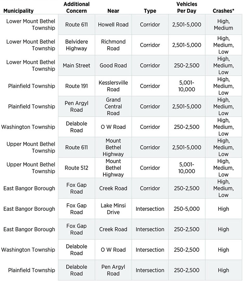
*Different sections of the same corridor can have High, Medium or Low crashes. The table reflects all the different crash conditions along the selected segment.
Summary
Transportation infrastructure is aging in the Slate Belt. At the same time, the area is experiencing increased impacts from heavy truck traffic associated with both existing businesses and business growth. Sidewalk infrastructure is concentrated in the boroughs and only exists in small portions of the townships. Multi-use trails serve recreational and possibly commuter needs within Plainfield Township, but there is a strong community desire to expand the network and connect more areas of the Slate Belt. Public bus transportation service exists to a limited extent in the eastern and northern portions of the region. Investments to enhancing the mixed-transportation infrastructure in the region will not only improve resident mobility and safety, but quality of life as well.
CLICK HERE FOR PRINT VERSION
Consultant, site maintained by Lehigh Valley Planning Commission