land analysis
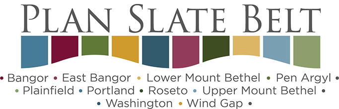
The Slate Belt is well known for its varied topography, beautiful landscape and historic boroughs. These fe atures—including natural areas and farmland—contribute significantly to the area’s unique identity and quality of life. Many of these areas are already under pressure from growth and development, and could face increased pressure if population growth forecasts prove to be true.
Plan Slate Belt will need to balance growth and development with preservation and conservation to maintain the look, feel and quality of life that residents greatly appreciate.
A Land Analysis was done to better understand some of the critical resources in the area and potential impacts of the current zoning. The analysis focused on two main elements: a review of the existing zoning for each municipality and calculation of the development potential of that zoning. These analyses were based on municipal zoning and land potentially available for development, which is land not currently developed, or protected lands such as parks and agricultural easements or natural resource lands. The results will be used to help guide development of policies, actions and implementation steps so the Slate Belt is able to get the kind and quality of development the area desires.
EXISTING LANDSCAPE
Natural Resources
The Slate Belt is rich with natural resources that enhance quality of life in the region. The Natural Resources map shows natural resources that are important to conserve, restore or enhance.
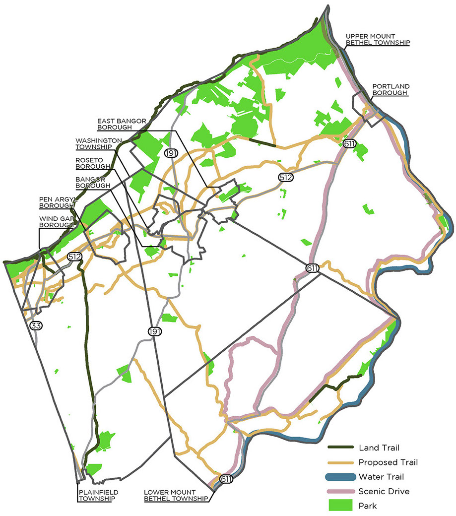
Farmland
Farming is highly valued in the Slate Belt both as a business and as a way to maintain the rural character of the area. Preserving farmland
through agricultural easements and establishing agricultural security areas are ways to maintain the character and quality of life of the Slate Belt.
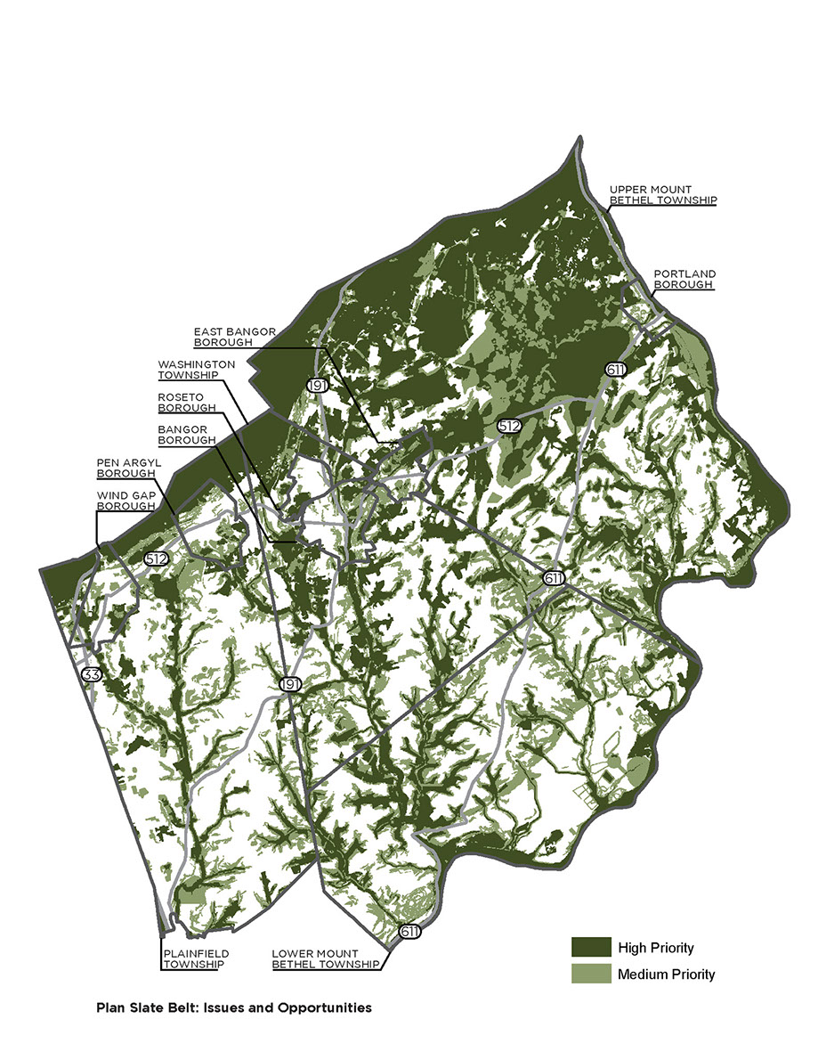
Parks, Recreation and Open Space
The Slate Belt has a wide variety of public and private parks, outdoor recreation, open space and scenic resources that provide health benefits to the residents of the region.
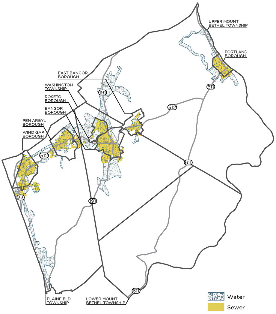
Water and Sewer
The Slate Belt has public water in the boroughs and denser areas of the townships. Public sewers are mostly in the boroughs and extend into small portions of the townships.
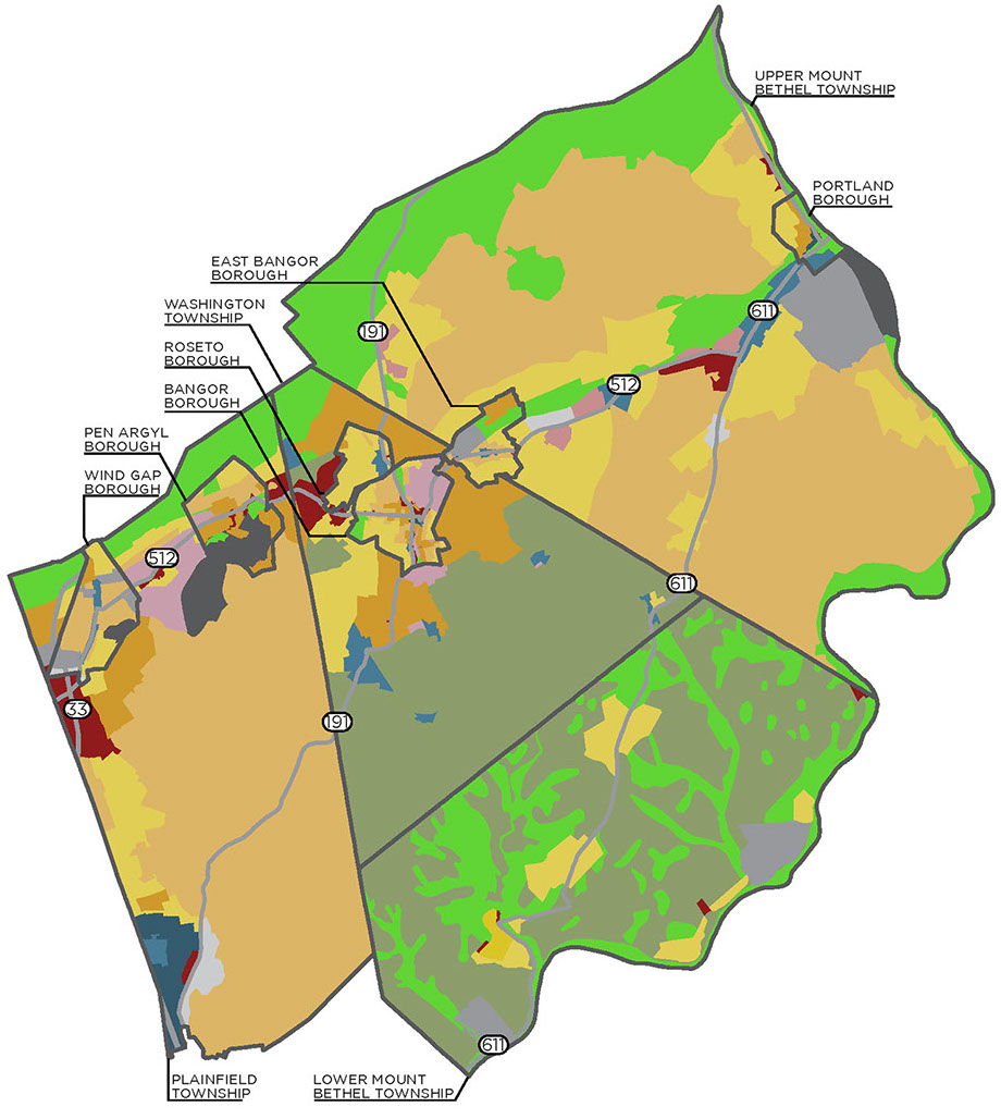
Municipal Zoning
The Slate Belt has large areas that are zoned for agricultural or rural districts, with higher intensity land uses concentrated in or around the boroughs and along the Route 512 corridor.
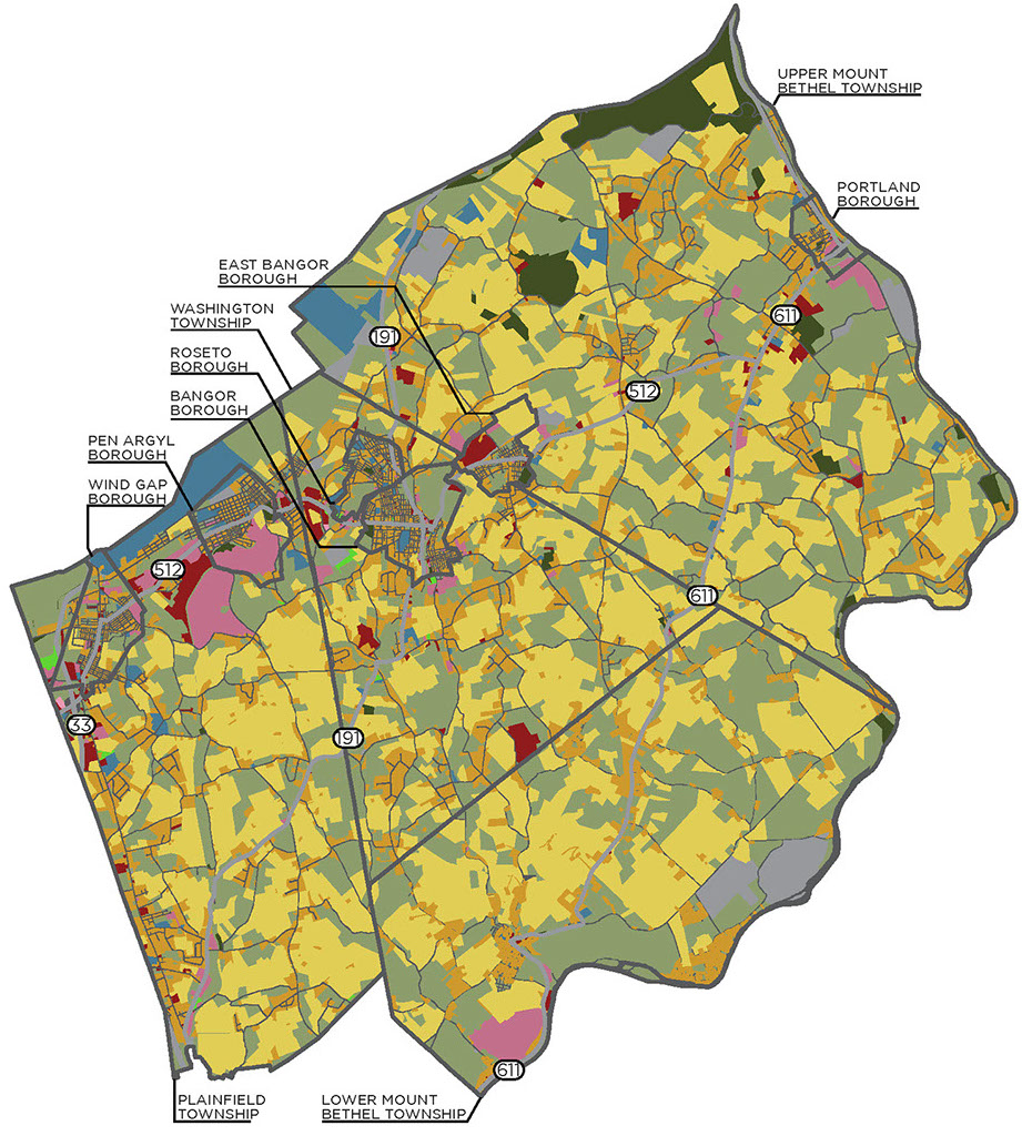
Existing Land Use
The Slate Belt has large areas devoted to agricultural and rural residential land uses. More intensive land uses tend to be clustered in and around the boroughs or near crossroads villages.
Zoning Review
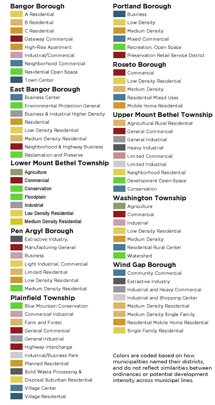
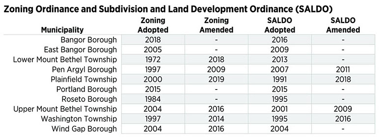
Municipal zoning ordinances were analyzed to identify the districts provided for in each municipality and the uses allowed under each district. The ordinances contain a variety of districts. The number of districts per ordinance ranged from five to 12. Mixed-use development is generally encouraged in the ordinances. Most of the ordinances have been completed and/or amended since 2005. Roseto Borough has the only ordinance dated before 2005.
Land Analysis
The Land Analysis is based on the data collected for the Zoning Review and estimates the future development potential of the existing zoning. It shows whether communities have enough land to accommodate future population growth. It is likely that the actual development intensity would be below these thresholds.
Overall, the Slate Belt has more than enough available land. However, much of this land is in agricultural areas. Furthermore, many of the boroughs have limited available land, requiring growth to be accommodated through revitalizing underused buildings or replacing existing development with higher intensity land uses. The Slate Belt should consider what type of development they want to see in the area and write their zoning codes to support that type of development.
Methodology
The total land potentially available for development was estimated by taking the total area of the Slate Belt and subtracting natural resources, preserved farmland, roadways and existing development. These remaining areas were identified by their respective zoning districts, and the total area within each district was calculated in acres.
The maximum potential density for both residential and non-residential land use was researched for each zoning district within each municipality. These densities were multiplied by the amount of total land potentially available for development within each zoning district to estimate the maximum number of units of housing and square footage of non-residential development.
The maximum density of housing units specified in the zoning code was used when available. When maximum densities were not easily available (typically for mixed-use or apartment land uses), the total square footage of building per acre was calculated based on maximum lot coverage and building height. This square footage was converted to an estimated number of housing units, with 800 square feet (a two-bedroom apartment) used for a typical unit unless a larger unit size was specified in the municipality’s zoning ordinance.
The density of non-residential land uses was calculated using maximum building coverage and maximum building height to calculate buildable square footage. This square footage was converted to square footage per acre for each zoning district.
Both residential and non-residential densities were calculated as if public sewer and water were available. While many areas do not currently have sewer or water access, the analysis assumes that access would be provided if development occurred at the highest possible intensity.
Because many of the zoning districts in the Slate Belt allow for both residential and non-residential land uses, the analysis was done with two scenarios: one that maximized housing units and one that maximized the square footage of non-residential development.
Maximum potential density was calculated based on total acres of available land within a zoning district, rather than available parcels. This method accounts for additions to existing buildings and accessory dwelling units, in addition to new development, but means that large developments may not work because the actual parcels may be too small.
BANGOR BOROUGH
Zoning Review
Bangor Borough completed a comprehensive update of their municipal zoning in 2018. The ordinance is divided into four residential districts and five non-residential districts, and is heavily weighted towards encouraging mixed-use development. Nearly every district allows for higher intensity residential or mixed-use development, with the exception of the Open Space District. The current code is comprehensive, with many land uses being allowed in multiple districts under specific circumstances.
Land Analysis
Bangor nearly has enough available land to accommodate projected population for the municipality, but only if the average number of people per household remains steady and new housing is built at the maximum potential density. Additionally, most of this housing development would need to be in the Industrial/Commercial District, which could compete with non-residential development.
Bangor can accommodate a large amount of non-residential growth in its Industrial/Commercial District—especially if that development is multi-story. However, other non-residential districts have much more limited space and are only able to accommodate a limited amount of growth.
Bangor will likely need to use a combination of revitalization, redevelopment and new development to accommodate growth and economic development.
New Housing Units Projected by 2040: 463
EAST BANGOR BOROUGH
Zoning Review
East Bangor Borough completed its municipal zoning in 2005. The ordinance is divided into three residential districts and five non-residential districts. Most of the districts allow for higher intensity residential or mixed-use development, with the exception of the Environmental Protection and Reclamation/Preserve districts. The General Business and Industrial District does not allow any residential or mixed-use development.
Land Analysis
East Bangor has more than enough available land to accommodate projected population for the municipality. The community would not need to maximize potential density under its existing zoning, but would still need to develop available land at a relatively high density for the Slate Belt area. While the Low-Density Residential District has the most potential acreage, the Medium-Density Residential District has the highest potential for accommodating future housing units.
East Bangor can accommodate a moderate amount of non-residential growth in each of its zoning districts. The highest potential exists in the Low-Density Residential District and would compete with new housing. However, other non-residential districts have much more limited space and are only able to accommodate a limited amount of growth.
East Bangor will likely need to use a combination of revitalization, redevelopment and new development to accommodate growth and economic development.
New Housing Units Projected by 2040: 194
LOWER MOUNT BETHEL TOWNSHIP
Zoning Review
Lower Mount Bethel Township completed its municipal zoning in 1972, and it was last amended in 2018. The Township is working on an updated ordinance. The existing ordinance is divided into two residential districts and five non-residential districts. Higher intensity residential or mixed-use development is allowed in only three of the districts. The Industrial District does not allow residential uses.
Land Analysis
Lower Mount Bethel Township has more than enough available land to accommodate projected population for the municipality and would not need to maximize potential density under their existing zoning. However, much of the potential housing could end up in areas zoned for agricultural use and undermine the rural character of the Township.
The Township can accommodate a high amount of non-residential growth in each of its zoning districts. The highest potential exists in the Agricultural and Low-Density Residential districts. While much of this area is restricted to agricultural-related businesses, high levels of non-residential development could significantly impact the quality of life and character of the community.
The Township will need to consider where and what kind of development it wants to accommodate growth, while maintaining its identity.
New Housing Units Projected by 2040: 715
PEN ARGYL BOROUGH
Zoning Review
Pen Argyl Borough completed its municipal zoning in 1997, and it was last amended in 2009. The ordinance is divided into three residential districts and four non-residential districts. Higher intensity residential or mixed-use development is allowed in four of the districts, maintaining separation of residential uses from the industrial/commercial districts.
Land Analysis
Pen Argyl is a well-developed borough with a relatively large amount of space available for development. The municipality has enough available land to accommodate projected population for the municipality, but would need to maximize potential density in key areas to meet future needs under their existing zoning. The highest potential exists in the Medium-Density Residential District, with smaller amounts of housing in other districts.
The Borough can also accommodate a moderate amount of non-residential growth. While the highest potential for non-residential also exists in the Medium-Density Residential District, the Low-Density and Limited Residential districts also have a relatively high potential for new development.
Pen Argyl will likely need to use a combination of revitalization, redevelopment and new development to accommodate growth and economic development.
New Housing Units Projected by 2040: 326
PLAINFIELD TOWNSHIP
Zoning Review
Plainfield Township compeleted its municipal zoning in 2000, and it was last amended in 2019. The ordinance is divided into three residential districts and nine non-residential districts. Higher intensity residential or mixed-use development is only allowed in four of the districts.
Land Analysis
Plainfield Township can accommodate a high amount of housing growth under its existing zoning code and does not need to maximize the density of its development to meet projected housing needs. However, much of the potential housing could end up in the Farm and Forest District, which is intended for agricultural use, and undermine the rural character of the township. The municipality’s zoning ordinance contains multiple development scenarios and different strategies to help preserve farmland, but does allow for five-acre lot subdivisions on most agricultural land. The municipality also has a large amount of area in the Suburban Residential District that could accommodate a variety of types and intensities of residential development. The Village Center and Village Residential districts also allow for high-intensity development that could draw pressure away from agricultural areas.
The Township can accommodate a high amount of non-residential growth in each of its zoning districts. The largest potential exists in the Farm and Forest District, as well as the Planned Residential District. While much of this area is restricted to agricultural-related businesses, high levels of non-residential development in these areas could significantly impact the character and quality of life of the community. Large amounts of non-residential growth could also be accommodated in the General Commercial, Highway Interchange and Industrial Business Park districts.
Plainfield will need to consider where and what kind of development it wants to accommodate growth, while maintaining its identity.
New Housing Units Projected by 2040: 1,194
PORTLAND BOROUGH
Zoning Review
Portland Borough completed an update to its municipal zoning in 2015. The ordinance is divided into two residential districts and four non-residential districts. Higher intensity or mixed-use development is allowed in four of the districts. No residential development is allowed in the Mixed Commercial or Recreation/Open Space Preservation districts.
Land Analysis
Portland is a well-developed borough with a relatively large amount of space available for development, given its small size. However, the municipality does not have enough available land to accommodate projected population growth. The Low-Density District has the highest potential, but would only be able to provide approximately half the projected housing demand if it was fully developed at the maximum allowed density.
The Borough can also accommodate a moderate amount of non-residential growth. The highest potential for non-residential exists in the Mixed Commercial District, though development would need to be multi-story to reach the maximum potential square footage. This district does not allow for residential, so commercial development would not compete with housing. However, the Low-Density District also has a high non-residential potential, and development in the district could limit the municipality’s ability to meet future housing needs.
Portland will likely need to use a combination of revitalization, redevelopment and new development to accommodate growth and economic development.
New Housing Units Projected by 2040: 145
ROSETO BOROUGH
Zoning Review
Roseto Borough completed its municipal zoning in 1984. The ordinance is divided into three residential and two non-residential districts. Higher intensity residential or mixed-use development is allowed in nearly all of the districts, except the Commercial District.
Land Analysis
Roseto is a well-developed borough with a very small amount of space available for development. The municipality does not have enough available land to accommodate the projected population growth. The largest potential exists in the Low-Density Residential District, but the highest allowed density would only meet a quarter of projected population demand.
The Borough also has very little space for new non-residential growth. The space that is available is in the same Low-Density Residential District. Non-residential development in the district would compete with projected housing demands.
Roseto will likely need to use a combination of revitalization, redevelopment and new development to accommodate growth and economic development.
New Housing Units Projected by 2040: 139
UPPER MOUNT BETHEL TOWNSHIP
Zoning Review
Upper Mount Bethel Township completed its municipal zoning in 2004, and it was last amended in 2016. The ordinance is divided into three residential districts and six non-residential districts. Higher intensity residential or mixed-use development is not allowed in the non-residential districts.
Land Analysis
Upper Mount Bethel Township has more than enough available land to accommodate projected population for the municipality and would not need to maximize potential density under existing zoning. The highest potential is in the Neighborhood Residential District, which could provide enough housing to meet future growth under multiple development scenarios. However, much of the potential housing could end up in the Agricultural Rural Residential District and undermine the rural character of the Township. This issue is created by a regulation in the ordinance that allows for up to two-acre lots.
The Township can also accommodate a high amount of non-residential growth under its existing zoning ordinance. The highest potential exists in the Agricultural Rural Residential, Neighborhood Residential and General Industrial districts. While the first two districts have restrictions on types of land use, the General Industrial District allows for a variety of high-intensity land uses. High levels of non-residential development in these districts could significantly impact the character and quality of life of the community.
The Township will need to consider where and what kind of development it wants to accommodate growth, while maintaining its identity.
New Housing Units Projected by 2040: 1,156
WASHINGTON TOWNSHIP
Zoning Review
Washington Township completed its municipal zoning in 1997, and it was last amended in 2014. The ordinance is divided into two residential districts and five non-residential districts. Higher intensity residential or mixed-use development is allowed in four of the districts, including the Agriculture District, which allows for residential development higher than one unit per acre.
Land Analysis
Washington Township has more than enough available land to accommodate projected population for the municipality and would not need to maximize potential density under their existing zoning. However, much of the potential housing could end up in the Agriculture District and undermine the rural character of the Township. This issue is created by a regulation in the ordinance that allows for up to 1.5 units per acre—a relatively high suburban density— that slowly diminishes rural areas. The Township also has a large amount of available land in the Low-Density Residential, Medium-Density Residential and Rural Center districts. Directing development towards these districts could reduce development pressure on agricultural areas.
The Township can accommodate a high amount of non-residential growth in each of its zoning districts. The highest potential exists in the Agriculture District. While much of this area is restricted to agricultural-related land uses, high levels of non-residential development in these areas could significantly impact the character and quality of life of the community. The Medium-Density Residential, Low-Density Residential, Rural Center and Commercial districts can also accommodate a significant amount of non-residential use.
The Towndship will need to consider where and what kind of development it wants to accommodate growth, while maintaining its identity.
New Housing Units Projected by 2040: 803
WIND GAP BOROUGH
Zoning Review
Wind Gap Borough completed its municipal zoning in 2004 and last amended its zoning in 2016. The ordinance is divided into four residential districts and four non-residential districts. Higher intensity residential or mixed-use development is allowed in nearly all the districts, except the Industrial/Heavy Commercial and Industrial/Shopping districts.
Land Analysis
Wind Gap is a well-developed borough with a relatively large amount of space available for development. The municipality has enough available land to accommodate the projected population for the municipality, but would need to maximize density in key areas to meet future needs under existing zoning. The largest potential exists in the Medium-Density Residential District and Extractive Industry District, with smaller amounts of housing in other districts.
The Borough can also accommodate a moderate amount of non-residential growth. The highest potential for non-residential growth exists in the Industrial and Heavy Commercial District, with other commercial and industrial districts also having significant potential.
Wind Gap will likely need to use a combination of revitalization, redevelopment and new development to accommodate growth and economic development.
New Housing Units Projected by 2040: 397
SUMMARY
The Slate Belt has a large amount of natural resources and farmland that give the region its distinct character and quality of life. However, projected population growth could put development pressure on a number of these areas. Under the existing zoning, the boroughs would struggle to provide for their projected population growth. The townships are in a much better position to accommodate future growth, but much of this new development could end up in agricultural areas under the existing zoning.
The Slate Belt will need to work together on how to best accommodate future growth and development. While revitalization, redevelopment and development of remaining areas within the boroughs can accommodate some of this growth, most will need to be in the townships. Where and how this growth occurs will have significant effects on the character and quality of life of the area.
Consultant, site maintained by Lehigh Valley Planning Commission